
The Amalfi Coast on Foot: Trails, Villages, and the Reality of Hiking There
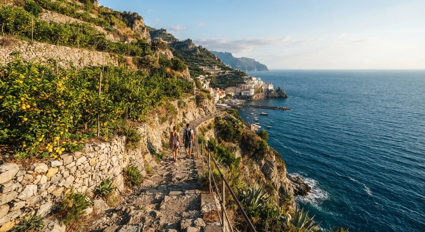
Photo credit: readerspanel.com
In this article
Beyond the postcard views, find out what hiking the Amalfi Coast actually involves, including terrain, crowds, and how to move between villages on foot.
Key Takeaways
- Most Amalfi Coast trails involve steep stone staircases rather than gentle countryside paths.
- The SITA ferry and bus network lets hikers combine walking with public transport between villages.
- Trails can be severely crowded from late spring through August; early morning starts matter.
- Always verify trail conditions with local tourism offices before heading out, as sections close seasonally.
- Heat, sun exposure, and uneven footing make proper footwear and water non-negotiable.
What the terrain actually looks like
The Amalfi Coast is not a national park with well-graded trails and signage every 500 meters. The paths here are mostly ancient mule tracks and stone staircases that connect villages before roads existed. That means vertical rather than gradual: the Sentiero degli Dei drops and climbs repeatedly, and the Ravello mule paths involve long staircase sections with no handrail.
The stone is often polished smooth by centuries of foot traffic, which makes it slippery when wet or dusty. Good tread matters more than technical difficulty. Anyone in reasonable fitness can complete these trails; the challenge is not endurance so much as steady attention to footing for several hours.
Crowds are a real part of the experience from late April through September. The Sentiero degli Dei in particular has become one of Italy's most photographed hikes, and the path width does not accommodate that volume gracefully. If solitude matters to you, the Ravello-to-Atrani mule path is far quieter and equally scenic.
What you will need
How to move between villages without a car
The SITA bus network is the practical backbone of car-free travel on the coast. Buses run along the SS163 between Salerno and Sorrento, stopping at most villages. They are inexpensive, accept cash, and run frequently enough in high season to make point-to-point hiking viable. The main drawback is the coastal road itself: it is narrow, winding, and the buses can be standing-room only in summer afternoons.
Ferries connect Amalfi, Positano, Cetara, Maiori, and Salerno directly by sea. The journey from Positano to Amalfi takes around 25 minutes by boat and avoids the bus crowds entirely. Ferry schedules are seasonal and conditions-dependent; check the day before rather than assuming the service runs year-round.
For the Sentiero degli Dei, the most efficient approach is a bus to Bomerano, hike to Nocelle, descend the stairs to Positano, and take the ferry home. That loop works in a single day without backtracking.
Hiking boots or trail shoes
The stone staircases and uneven limestone paths cause ankle rolls in soft-soled footwear.
Trekking poles
Significantly reduce knee strain on the long descents into Nocelle or Praiano.
Offline map app or paper CAI map
Cell signal disappears frequently along cliff-side trail sections.
Sun protection (hat, SPF, sunglasses)
Exposed ridgeline trails offer almost no shade between June and September.
SITA bus pass or ferry tickets
Allows one-way hiking with a transport return rather than retracing the full route.
The step-by-step plan
Choose your trail based on fitness and time
The Amalfi Coast has three trails that most hikers actually complete. The Sentiero degli Dei (Path of the Gods) runs roughly 7.8 km from Bomerano to Nocelle, with about 300 meters of descent and near-continuous sea views. It takes most hikers two to three hours one-way. The Valle delle Ferriere is a gorge walk from Amalfi town through lemon and paper-mill ruins to a waterfall; it is shorter and shadier, around 4 km out-and-back. The Ravello-Minuta-Atrani loop connects hill villages on mule paths that most tourists skip entirely, roughly 8 km with mixed elevation.
Pick one trail per day. Combining two in summer heat is harder than it looks on a map.
Verify current trail conditions before you go
Sections of the Amalfi Coast trail network close every winter for landslide repair, and not all reopen on the same schedule. The CAI sections that manage these paths post closure notices, and the local tourism offices in Amalfi and Positano maintain updated status lists. Check within a week of your planned hike, not just at booking time.
The Valle delle Ferriere in particular has had recurring partial closures after heavy rain. Do not rely on year-old forum posts to confirm it is open.
Start by 7:30 a.m. during spring and summer
By 10 a.m. in July, the Sentiero degli Dei has hundreds of hikers on a path that is sometimes only a meter wide. An early start gives you cooler temperatures, better light for photography, and enough space to actually stop and look around. Ferries and SITA buses to Bomerano run early enough to make this workable even if you are staying in Amalfi or Positano.
Plan your exit from each trailhead
Most Amalfi Coast trails are point-to-point, not loops. Finishing at Nocelle means descending roughly 1,500 stone steps to Positano, which takes 30 to 45 minutes on tired legs, or paying for a shared taxi. From Atrani you can walk the short flat seafront path to Amalfi town. From the Valle delle Ferriere you return the same way you came.
Check the SITA bus timetable in advance. Buses on the coastal road run frequently in summer but can be packed to standing-room only. Ferries between Amalfi, Positano, and Salerno are a more comfortable option and worth the slightly higher fare.
Build in time for the villages themselves
Ravello sits 350 meters above sea level with its own walking paths through gardens and medieval lanes. Atrani is the smallest municipality on the coast and almost entirely skipped by day-trippers. Minori has a Roman villa with mosaic floors that most visitors walk past without realizing it is there (admission is low and lines are short).
A hiking itinerary that ignores the villages misses half the reason to be on foot in the first place. Budget at least 90 minutes per village if you plan to stop.
Pack and dress for the actual conditions
Temperatures on exposed ridgelines can be 5 to 8 degrees Celsius warmer than in Amalfi town below. Carry more water than you think you need; fountains marked on older maps are not always running. A light rain layer is worth the pack space even in summer, since coastal weather changes quickly in the late afternoon.
Wear shoes you have already broken in. Blisters from new footwear on steep stone are miserable two hours from the nearest road.
What to know before you go
Italy does not maintain the same trail infrastructure as, say, national park systems in the US. Signage is inconsistent, some waymarks have faded, and trail maps in English vary in accuracy. The CAI (Club Alpino Italiano) publishes the most reliable maps, and local tourism offices in Amalfi and Positano are genuinely helpful for current conditions.
Travel insurance that covers hiking activity is worth having. Check your policy before you leave, since some base travel policies exclude walking above a certain elevation or on ungraded paths. For any medical question or concern specific to your fitness level before attempting these trails, consult your doctor rather than relying on general guidance.
Entry requirements, ferry schedules, and trail closure policies change. Verify all logistics through official Italian tourism sources and your government's travel advisory before booking.
This article is for informational purposes only. Trail conditions, ferry schedules, and entry requirements can change; always verify with official sources and local authorities before traveling.

Author
Travel & Adventure Editorial Team
Travel & Adventure Editorial Team is the collective byline for our editorial team and contributor network. Articles published under this byline or an editorial pen name are researched, written, and reviewed according to our editorial standards for clarity, consistency, and independence before publication.
View all articles →